-
1 поле допуска перпендикулярности оси (или прямой) относительно плоскости в заданном направлении
- Zone der Richtwinkligkeitstoleranz einer Geraden zu einer Ebene in einer vorgegebenen Richtung
поле допуска перпендикулярности оси (или прямой) относительно плоскости в заданном направлении
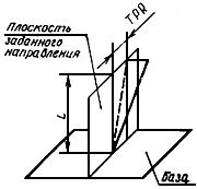
Область на плоскости заданного направления, ограниченная двумя параллельными прямыми, отстоящими друг от друга на расстоянии, равном допуску перпендикулярности TPR и перпендикулярности к базовой плоскости.
[ ГОСТ 24642-81]Тематики
Обобщающие термины
EN
- tolerance zone of perpendicularity of a line with reference to a datum surface in the specified direction
DE
- Zone der Richtwinkligkeitstoleranz einer Geraden zu einer Ebene in einer vorgegebenen Richtung
FR
- zone de tolérance de perpendicularité d'une ligne par rapport à une surface, dans la direction de la flèche
Русско-немецкий словарь нормативно-технической терминологии > поле допуска перпендикулярности оси (или прямой) относительно плоскости в заданном направлении
-
2 граница между воздухом и поверхностью океана
граница между воздухом и поверхностью океана
—
[ http://www.eionet.europa.eu/gemet/alphabetic?langcode=en]EN
ocean-air interface
The sea and the atmosphere are fluids in contact with one another, but in different energy states - the liquid and the gaseous. The free surface boundary between them inhibits, but by no means totally prevents, exchange of mass and energy between the two. Almost all interchanges across this boundary occur most effectively when turbulent conditions prevail. A roughened sea surface, large differences in properties between the water and the air, or an unstable air column that facilitates the transport of air volumes from sea surface to high in the atmosphere. Both heat and water (vapor) tend to migrate across the boundary in the direction from sea to air. Heat is exchanged by three processes: radiation, conduction, and evaporation. The largest net exchange is through evaporation, the process of transferring water from sea to air by vaporization of the water. (Source: PARCOR)
[http://www.eionet.europa.eu/gemet/alphabetic?langcode=en]Тематики
EN
DE
FR
Русско-немецкий словарь нормативно-технической терминологии > граница между воздухом и поверхностью океана
-
3 пещера
пещера
—
[ http://www.eionet.europa.eu/gemet/alphabetic?langcode=en]EN
cave
1) An underground hollow with access from the ground surface or from the sea, often found in limestone areas and on rocky coastlines.
2) A natural cavity, chamber or recess which leads beneath the surface of the earth, generally in a horizontal or obliquely inclined direction. It may be in the form of a passage or a gallery, its shape depending in part on the joint pattern or structure of the rock and partly on the type of process involved in its excavation. Thus, caves worn by subterranean rivers may be different in character from, and of considerably greater extent than, a sea-cave eroded by marine waves.
3) A natural underground open space, generally with a connection to the surface and large enough for a person to enter. The most common type of cave is formed in a limestone by dissolution.
(Source: CED / WHIT / BJGEO)
[http://www.eionet.europa.eu/gemet/alphabetic?langcode=en]Тематики
EN
DE
FR
Русско-немецкий словарь нормативно-технической терминологии > пещера
-
4 зона досягаемости рукой
зона досягаемости рукой
Зона доступного прикосновения, простирающаяся от любой точки поверхности, на которой обычно находятся или передвигаются люди, до границы, которую можно достать рукой в любом направлении без использования дополнительных средств.
[ ГОСТ Р МЭК 60050-195-2005]
[ ГОСТ Р МЭК 60050-826-2009]
Это пространство условно ограничено, как показано на рисунке
В.1
S-поверхность, на которой может находиться человек
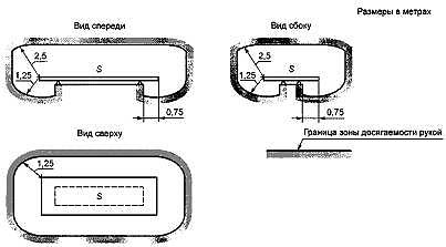
Рисунок В.1 - Зона досягаемости рукой
[ ГОСТ Р 50571. 1-2009 ( МЭК 60364-1: 2005)]EN
arm's reach
zone of accessibility to touch extending from any point on a surface where persons usually stand or move about to the limits which a person can reach with the hand, in any direction, without assistance
Source: 826-03-11 MOD
[IEV number 195-06-12]FR
volume d'accessibilité au toucher
zone s'étendant entre tout point de la surface où les personnes se tiennent et circulent habituellement, et la limite qu'une personne peut atteindre avec la main, dans toutes les directions, sans moyen auxiliaire
Source: 826-03-11 MOD
[IEV number 195-06-12]Тематики
EN
DE
FR
Русско-немецкий словарь нормативно-технической терминологии > зона досягаемости рукой
-
5 скользящий электрический контакт
cкользящий электрический контакт
Электрический контакт, существующий при скольжении одной контакт-детали по другой
[ ГОСТ 14312-79]
cкользящий контакт
Контакт при котором одна из деталей перемещается (скользит) относительно другой, но электрический контакт при этом не нарушается. Например, контакты реостатов, щеточный контакт электрических машин, шарнирный контакт.
[В. В. Скрежендевский. Электрооборудование тепловозов. Учемно-методическое пособие. Часть 1. Белорусский государственный универститет транспорта. Гомель 2008 г.]EN
sliding contact
a contact in which relative movement of the contact pieces is substantially in a direction parallel to the contact surface
[IEV number 441-15-15 ]FR
contact glissant
contact dont les pièces se déplacent pratiquement parallèlement à la surface de contact
[IEV number 441-15-15 ]Тематики
Обобщающие термины
Синонимы
EN
DE
FR
Русско-немецкий словарь нормативно-технической терминологии > скользящий электрический контакт
-
6 циркуляция морской воды
циркуляция морской воды
—
[ http://www.eionet.europa.eu/gemet/alphabetic?langcode=en]EN
sea circulation
Large-scale horizontal water motion within an ocean. The way energy from the sun, stored in the sea, is transported around the world. The currents explain, for example, why the UK has ice-free ports in winter, while St. Petersburg, at the same latitude as the Shetland Islands, needs ice breakers. Evidence is growing that the world's ocean circulation was very different during the last ice age and has changed several times in the distant past, with dramatic effects on climate. The oceans are vital as storehouses, as they absorb more than half the sun's heat reaching the earth. This heat, which is primarily absorbed near the equator is carried around the world and released elsewhere, creating currents which last up to 1.000 years. As the Earth rotates and the wind acts upon the surface, currents carry warm tropical water to the cooler parts of the world. The strength and direction of the currents are affected by landmasses, bottlenecks through narrow straits, and even the shape of the sea-bed. When the warm water reaches polar regions its heat evaporates into the atmosphere, reducing its temperature and increasing its density. When sea-water freezes it leaves salt behind in the unfrozen water and this cold water sinks into the ocean and begins to flow back to the tropics. Eventually it is heated and begins the cycle all over again. (Source: MGH / WRIGHT)
[http://www.eionet.europa.eu/gemet/alphabetic?langcode=en]Тематики
EN
DE
FR
Русско-немецкий словарь нормативно-технической терминологии > циркуляция морской воды
См. также в других словарях:
Surface reconstruction — refers to the process by which atoms at the surface of a crystal assume a different structure than that of the bulk. Surface reconstructions are important in that they help in the understanding of surface chemistry for various materials,… … Wikipedia
SURFACE (PHÉNOMÈNES DE) — La surface d’un solide ou d’un liquide est une région s’étendant sur quelques distances atomiques qui sépare l’intérieur du matériau du milieu extérieur: en général, le vide ou un gaz. Si le milieu extérieur est une autre phase dense, liquide ou… … Encyclopédie Universelle
Surface weather observation — Surface weather observations are the fundamental data used for safety as well as climatological reasons to forecast weather and issue warnings worldwide. [Office of the Federal Coordinator of Meteorology. [http://www.ofcm.gov/fmh 1/pdf/B CH2.pdf… … Wikipedia
Surface efficace radar — Surface équivalente radar Pour les articles homonymes, voir SER et Surface (homoymie). Exemple de diagramme de surface équivalente radar (d après Skolnik) … Wikipédia en Français
Surface equivalente radar — Surface équivalente radar Pour les articles homonymes, voir SER et Surface (homoymie). Exemple de diagramme de surface équivalente radar (d après Skolnik) … Wikipédia en Français
surface — [ syrfas ] n. f. • 1611; superface 1521; lat. superficies → superficie; de sur et face 1 ♦ Partie extérieure (d un corps), qui le limite en tous sens. ⇒ face. La surface de la Terre, la surface terrestre. À la surface du sol. « une surface pure… … Encyclopédie Universelle
Surface de trainee — Surface de traînée En mécanique des fluides, la surface de traînée est une grandeur qui permet de quantifier la force de résistance à l avancement Fx ou traînée d un corps. Sommaire 1 Expression de la traînée 1.1 pression dynamique 1.2 su … Wikipédia en Français
Surface irrigation — is defined as the group of application techniques where water is applied and distributed over the soil surface by gravity. It is by far the most common form of irrigation throughout the world and has been practiced in many areas virtually… … Wikipedia
Surface d'onde — ● Surface d onde ensemble des points où une composante spécifiée d une onde périodique a la même phase au même instant. (La normale à la surface d onde en un point est la direction de propagation.) … Encyclopédie Universelle
Surface prismatique — ● Surface prismatique surface engendrée par le déplacement d une droite de direction fixe qui s appuie sur un contour polygonal … Encyclopédie Universelle
Surface de niveau — Verticale et surface de niveau Verticale et surfaces de niveau mettent en évidence les dénivellations affectant un territoire géographique lorsqu il est représenté sur un plan. La verticale d un point de la surface est une ligne imaginaire… … Wikipédia en Français